
| Brook to Chilbolton |
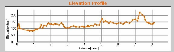
Long straight walk, all on the Test Way. GPX says 8.1 miles; GPS said we walked 8.54 miles. Follows the course of the old Sprat and Winkle railway line to Chilbolton Cow Meadow. It's pretty flat, except for a little climb over West Down at Testcombe . The parking for the start of the walk is in a layby at Brook. At the end it's in the car park at Chilbolton Cow Common. There are a few notable hostelries along this route: the John O'Gaunt at Horsebridge; The White Hart, Stockbridge; and The Mayfly, at Testcombe. Park on the red circle below, and either load the GPX file into your GPS, or follow the TW signs. You can scroll the map below simply by moving the mouse with the left-button held down.
|
|

© Copyright Chris Talbot and licensed for reuse under this Creative Commons Licence
To download GPX Files, right-click the link, choose Save Link As ..., and save it to wherever you keep route files.
See the documentation that came with your GPS for information on how to download the route to your GPS.
These are a selection of Ordnance Survey Maps that cover this walk.
Geocaches on route
Sprat and Winkle Line (GC8725)
SideTracked no more - Horsebridge (GC1H9ZE)
Sidetracked No More (Stockbridge) (GC1VXM7)
There are caches nearby: see them on Google Maps by mapping any of the above caches.
Blog
Photos